Category Archives: Land Mapping

GPS and GIS mapping of your property

Coal Ash Pond Bathymetry and Dredge Survey

The Mapping Network performed a hydrographic and dredge survey for a power plant’s coal ash ponds. These can be difficult because of the composition of material.  With the combination our sonar, GPS, and years of experience with coal ash, we were able to give them an accurate estimate of ash volume.

Sediment_NearmanPowerPlant - Copy_001

Land and Water Topography of Pipeline in Missouri

The Mapping Network and an engineering firm team up to perform a topographic survey on the land and a hydrographic survey on a portion of the lake where a new gas pipeline would be crossing.  The pipeline is buried  below the lake bottom and knowing the existing bottom of the lake is crucial to engineers placing the pipeline correctly.

Pipeline5.jpg

3D rendering showing the results of the topographical and hydrographic survey.   The proposed pipeline is noted in the image.

About The Mapping Network: 

The Mapping Network is an industry leader in Geographic Information Systems, GPS Data Collection, Aerial Imagery, and Data Conversion.  We specialize in terrain and sub-surface (bathymetry) GPS mapping, topographic mapping, and aerial imagery.  Give us a call or send an e-mail to find out more details.

phone:  (402) 241-8177

e-mail: info@themappingnetwork.com

website: www.themappingnetwork.com

Check out The Mapping Network on Twitter or Facebook for more examples and success stories!

High Resolution Topography and Bathymetry

The Mapping Network utilized sonar for collecting water depths and drone technology to collect elevation data surrounding the pond to create an accurate 3D model.  This model was used to calculate a water capacity chart and help meet a federal mandate.

3D_drone.jpg

Elevation both in the pond and on the surrounding land.   Water capacity was generated from 3D model

About The Mapping Network: 

The Mapping Network is an industry leader in Geographic Information Systems, GPS Data Collection, Aerial Imagery, and Data Conversion.  We specialize in terrain and sub-surface (bathymetry) GPS mapping, topographic mapping, and aerial imagery.  Give us a call or send an e-mail to find out more details.

phone:  (402) 241-8177

e-mail: info@themappingnetwork.com

website: www.themappingnetwork.com

Check out The Mapping Network on Twitter or Facebook for more examples and success stories!

GPS Maps for Habitat Improvement Planning

Absolute Natural Resources and The Mapping Network provide extensive land and habitat GPS mapping services involving the use of complex data collection methods, state of the art GIS and GPS technology and satellite imagery.  Absolute Natural Resources offers a variety of mapping services and products for real estate professionals, private landowners, fishing and hunting clubs, habitat and lake developers, hunting lease managers, timber management firms, and recreational land companies.  Located in Denver, Colorado, Absolute Natural Resources has the experience to handle mapping projects in the steep terrain of the Rocky Mountains to the gentle hills of the Great Plains region.  Common client requests include, but are not limited to, aquatic vegetation beds, wetlands, streams, irrigation canals, inlet and outlet features, dam facilities, habitat structures, boat ramps, fishing piers, duck blinds, waterfowl nests and site-specific channels.A recent project for a client included creating a detailed Nebraska waterfowl habitat plan to allow the land owner to visualize and study the feasibility of constructing a world-class hunting destination.More information on Absolute Natural Resources, LLC can be found on their website:  www.anrwildlife.com

GPS Waterfowl Habitat Improvement Map

GPS Waterfowl Habitat Improvement Map

The Mapping Network is an industry leader in Geographic Information Systems Consulting, Data Conversion, and GPS Data Collection.  We specialize in terrain and sub-surface (bathymetry) GPS mapping.   If you are serious about maintaining  a high-quality golf course, lake or pond, be sure you have the ability to make the best decisions,  get your resource mapped by the professionals at The Mapping Network.   Give us a call or send an e-mail to find out more details.

phone:  (402) 241-8177

e-mail: info@themappingnetwork.com

website: www.themappingnetwork.com

Check out The Mapping Network on Facebook for more examples and success stories!

The Mapping Network is proud to announce their firm has been chosen by Cabela’s, the World’s Foremost Outfitter, as a Landowner Services provider for Cabela’s Trophy Properties throughout the United States.  Visit us on the Cabela’s Trophy Properties website >> click here

Top Recreational Experts Choose The Mapping Network

Chris Bober Uses The Mapping Network for Recreational Real Estate

By Chris Bober, Sales Associate for Premier Outdoor Properties licensed in Nebraska and Kansas

One of the greatest services I can provide to buyers and sellers with is a comprehensive view of recreational property. Premier Outdoor Properties has a distinct advantage because we have a unique affiliation with The Mapping Network, a nationwide group of professionals who provide the highest quality and most affordable bathymetric and land mapping products on the market today.

The Mapping Network

The Mapping Network collects data and creates maps for properties that can give the landowners we work with the latest mapping and analysis technology. They offer aquatic services that highlight the dynamics of lake property as well as improving habitat or designing a plan for building a lake or pond. They help us by highlighting the best assets of our listings and by using their innovative products to create specific maps to display to potential buyers.

As a partner with their company, some of the properties that we map can even be put on their website as an added referral network for your property. They provide us with the best services, which we then pass onto you. If you are looking to buy or sell recreational property, Premier Outdoor Properties, myself, and the Mapping Network can provide mapping services to highlight a property’s best qualities and unique attributes.

Thank you Steve Bartosh and Tyler Van Meeteren for helping me highlight your services. They have done countless maps for me in the past and have helped pave the way to making buyers extremely gratified and sellers exceptionally satisfied.

Check out an example map on the Premier Outdoor Properties Website

Remember sometimes experiencing the outdoors means knowing everything a property has to offer. The Mapping Network combined with Premier Outdoor properties can give you that information. Experiencing the Outdoors has never been more precise.

Visit The Mapping Network’s Website

Virtual Fly Over on YouTube to Promote Recreational Real Estate Sales

Mike Lashley (Lashley Land & Recreational Brokers) utilizes every cutting edge technology to market his Nebraska recreational properties for sale.  Since a large number of buyers come from out of state or even hundreds of miles away in-state, it is critical to help potential buyers gain a feel for the land from their home or office before spending time and money to visit properties.  Mike Lashley has teamed up with The Mapping Network for all GPS and GIS mapping products to generate interest for his listings.  Using YouTube to show virtual flyovers of properties gives Mr. Lashley a significant competitive advantage in the recreational land market.

Nebraska Hunting Land For Sale This Is One Amazing Piece of Nebraska Real Estate. 3/4 Mile of Niobrara River Frontage and Over 1 Mile of Lucky Creek Running Through the Ranch.

You will have to look long and hard to find a ranch like this one.  Niobrara River frontage, live creek water, secluded alfalfa fields and tremendous rugged canyon land that is 80% tree covered.  There are White-tailed Deer, Mule Deer, Merriams Wild Turkey all in abundance.

The ranch borders the Thomas Creek Wildlife Management Area.  This is over 1,000 acres of Public Land that is walk-in only hunting.  This makes it extremely hard for the Public to get to the back side.  It’s like having an extra 1,000 + acres to hunt.  What makes this one of the finest deer hunting spots is the 89 acres of alfalfa.  These fields are surrounded by tremendous bedding cover.  It’s a huge food plot that is miles from the nearest road.  I drove my Polaris Ranger within 40 yards of 4 White-tailed Deer.  They rarely see people.  There is a cozy 4 bedroom, 3 bath house with garage and a good metal building included.  The current owner would stay on as a tenant and caretaker.  More road development could be made to improve the ranch.  The current owner has the equipment and know how to do both.

For More information on this listing click here:  http://www.lashleyland.com/realestate/luckycreek_ranch.html

View other Nebraska hunting properties from Lashley Land: www.lashleyland.com

View Property Virtual Fly-Over on You Tube:  Click for Virtual Tour

Click her for Aerial Map (pdf): Aerial Map of Nebraska Hunting Land For Sale

Nebraska Hunting Land For Sale - This Is One Spectacular Piece of Nebraska Real Estate. 3/4 Mile of Niobrara River Frontage and Over 1 Mile of Lucky Creek Running Through the Ranch. Nebraska River Land For Sale – Waterfowl, Deer and Turkey Hunting
Nebraska Hunting Land For Sale – This Is One Spectacular Piece of Nebraska Real Estate. 3/4 Mile of Niobrara River Frontage and Over 1 Mile of Lucky Creek Running Through the Ranch. Nebraska River Land For Sale – Waterfowl, Deer and Turkey Hunting

The Mapping Network: www.TheMappingNetwork.com A Nationwide Network of GPS Mapping Professionals

Nebraska Hunting Land For Sale – This Is One Spectacular Piece of Nebraska Real Estate. 3/4 Mile of Niobrara River Frontage and Over 1 Mile of Lucky Creek Running Through the Ranch.

Nebraska River Land For Sale – Waterfowl, Deer and Turkey Hunting

Land Mapping, Cabelas Hunting Land, Cabelas Land, Cabelas Land For Sale, Cabelas River, Cabelas Trophy Properties, GPS Map, Habitat, Hunting Land, Hunting Property, Land For Sale, Lashley Land, Nebraska, Nebraska Hunting, Nebraska Hunting Land, Nebraska Land For Sale, Nebraska Waterfowl, River Land For Sale, The Mapping Network, Waterfowl

Kansas City Bathymetry and Property GPS Mapping

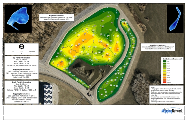
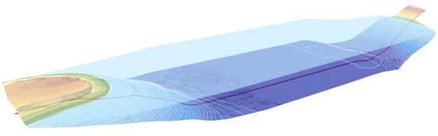
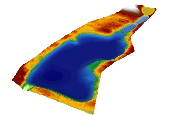
The Mapping Network and Absolute Natural Resources teamed up for a mapping project on the western edge of Kansas City, Kansas.  The client, a Home Owner Association, requested the creation of a detailed property and lake map which will then be distributed throughout the community.  Mapping the lake on the property allows for proper management of largemouth bass, crappie, blue gill and catfish populations by knowing exact depths and acreage for stocking densities and vegetation control.  Over 30 sediment depth samples were also collected in the field and placed on a separate map.  The maps are a handy tool for families and guests to the community by showing all trails and fishing hot spots.

Absolute Natural Resources provides extensive land and habitat GPS mapping services involving the use of complex data collection methods, state of the art GIS and GPS technology and satellite imagery.  Absolute Natural Resources offers a variety of mapping services and products for real estate professionals, private landowners, fishing and hunting clubs, habitat and lake developers, hunting lease managers, timber management firms, and recreational land companies.

Located in Denver, Colorado, Absolute Natural Resources has the experience to handle mapping projects in the steep terrain of the Rocky Mountains to the gentle hills of the Great Plains region.  Common client requests include, but are not limited to, aquatic vegetation beds, wetlands, streams, irrigation canals, inlet and outlet features, dam facilities, habitat structures, boat ramps, fishing piers, duck blinds, waterfowl nests and site-specific channels.

More information on Absolute Natural Resources, LLC can be found on their website:  www.anrwildlife.com

Aerial map showing lake depths, trails, and other features of the lake community

The Mapping Network:  www.TheMappingNetwork.com

A Nationwide Network of GPS Mapping Professionals

GPS Maps of Hunting Land and Lakes – Improve Property Management

With the fall hunting season just getting started, how would you like to have a detailed map of your property with the latest aerial imagery?  Want your deer stands, trails, food plots, property boundary, ponds, streams, deer cameras, etc placed on a master map?  The Mapping Network, and its mapping partners offer an extensive set of land and habitat GPS mapping services involving the use of highly accurate data collection methods, state of the art GIS and GPS technology and satellite imagery.  The Mapping Network offers a variety of mapping services and products for real estate professionals, private landowners, fishing and hunting clubs, habitat and lake developers, hunting lease managers, timber management firms, and recreational land companies.  The Mapping Network has service providers conveniently located throughout the country with the experience to handle mapping projects in any terrain or environment.  Common client requests include, but are not limited to, aquatic vegetation beds, wetlands, streams, irrigation canals, inlet and outlet features, dam facilities, habitat structures, boat ramps, fishing piers, duck blinds, waterfowl nests and site-specific channels.  Our mapping specialists will assist in the collection of key property data and work with you throughout the map making process.

A recent project for a client included creating a detailed Nebraska habitat plan to allow the land owner to visualize and study the feasibility of constructing a world-class hunting and fishing destination.  Mapping the three lakes on the property allows proper management of largemouth bass by knowing exact depths and acreage for stocking densities and vegetation control.  The maps are a handy tool for guests to the ranch by showing all trails and fishing hot spots.

To locate a GPS mapping provider near you please check out the The Mapping Network’s Partner Page:  http://www.TheMappingNetwork.com

GPS Habitat Map
GPS Habitat and Lake Map

The Mapping Network:  www.TheMappingNetwork.com

A Nationwide Network of GPS Mapping Professionals

GPS Maps of Hunting Land and Lakes – Improve Property Management

Absolute Natural Resources provides extensive land and habitat GPS mapping services involving the use of complex data collection methods, state of the art GIS and GPS technology and satellite imagery.  Absolute Natural Resources offers a variety of mapping services and products for real estate professionals, private landowners, fishing and hunting clubs, habitat and lake developers, hunting lease managers, timber management firms, and recreational land companies.  Located in Denver, Colorado, Absolute Natural Resources has the experience to handle mapping projects in the steep terrain of the Rocky Mountains to the gentle hills of the Great Plains region.  Common client requests include, but are not limited to, aquatic vegetation beds, wetlands, streams, irrigation canals, inlet and outlet features, dam facilities, habitat structures, boat ramps, fishing piers, duck blinds, waterfowl nests and site-specific channels.

A recent project for a client included creating a detailed Nebraska habitat plan to allow the land owner to visualize and study the feasibility of constructing a world-class hunting and fishing destination.  Mapping the three lakes on the property allows proper management of largemouth bass by knowing exact depths and acreage for stocking densities and vegetation control.  The maps are a handy tool for guests to the ranch by showing all trails and fishing hot spots.

More information on Absolute Natural Resources, LLC can be found on their website:  www.anrwildlife.com

GPS Habitat Map

GPS Habitat and Lake Map

The Mapping Network:  www.TheMappingNetwork.com

A Nationwide Network of GPS Mapping Professionals

GPS Maps for Habitat Improvement Planning

Absolute Natural Resources provides extensive land and habitat GPS mapping services involving the use of complex data collection methods, state of the art GIS and GPS technology and satellite imagery.  Absolute Natural Resources offers a variety of mapping services and products for real estate professionals, private landowners, fishing and hunting clubs, habitat and lake developers, hunting lease managers, timber management firms, and recreational land companies.  Located in Denver, Colorado, Absolute Natural Resources has the experience to handle mapping projects in the steep terrain of the Rocky Mountains to the gentle hills of the Great Plains region.  Common client requests include, but are not limited to, aquatic vegetation beds, wetlands, streams, irrigation canals, inlet and outlet features, dam facilities, habitat structures, boat ramps, fishing piers, duck blinds, waterfowl nests and site-specific channels.

A recent project for a client included creating a detailed Nebraska waterfowl habitat plan to allow the land owner to visualize and study the feasibility of constructing a world-class hunting destination.

More information on Absolute Natural Resources, LLC can be found on their website:  www.anrwildlife.com

GPS Waterfowl Habitat Improvement Map

GPS Waterfowl Habitat Improvement Map

The Mapping Network:  www.TheMappingNetwork.com

A Nationwide Network of GPS Mapping Professionals