Please visit our current website at www.themappingnetwork.com


Please visit our current website at www.themappingnetwork.com

Do you enjoy working on lakes? Creating maps? We are currently seeking a hydrographer / geoscience professional for the position of a Hydrographic Surveyor / GIS Analyst in Kansas City, Missouri. This position requires a high-energy leader who has a passion for the geographic industry. This person will interact with other industry professionals throughout the United States.
About Us:
The Mapping Network is a business organized to perform hydrographic, sediment, and UAV surveys on land, lakes and river systems for a wide range of clients throughout the United States. We operate from our office in Kansas City, Missouri along with fifteen highly trained professional companies located around the country. We provide this service for a variety of client needs including generating bathymetry, sediment volume, dredging, topography, and water volume information.
The Mapping Network works directly with engineers, dredging companies, lake associations, developers and government organizations. With over 1800 completed hydrography projects, our company and personnel have been leaders in the development of technology for over a decade.
Job Position:
Full-time Hydrographic Surveyor / GIS Analyst
Position Location:
Kansas City, MO with required travel
Job Summary:
The Hydrographic Surveyor / GIS Analyst will provide data collection and processing services on lakes, land and rivers throughout the US. Position resides in Kansas City, MO.
Position Reports to:
Company President
Overall Function:
This position will provide data collection and processing services on lakes, land and rivers throughout the US. Some projects are local, most will require travel.
Overall Responsibilities:
Key skills/attributes:
Desired Qualifications:
The Mapping Network is an Equal Opportunity Employer and all qualified applicants will receive consideration for employment without regard to race, color, religion, sex, national origin, disability, protected veteran status, or any other characteristic protected by law.
Please send resume and salary requirements to steve@themappingnetwork.com
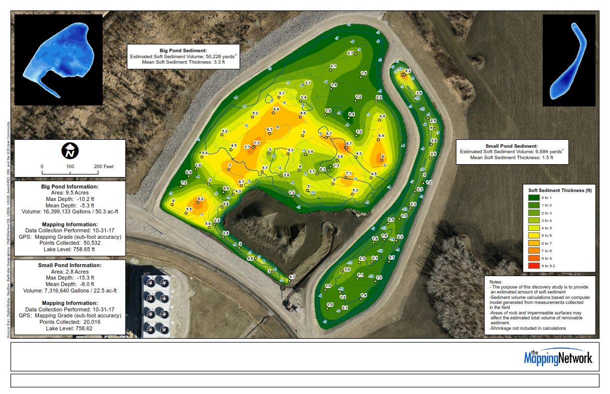
A hydrographic and sediment study was recently conducted on a retention pond to provide a information to help with proper management. It’s important to know how much sediment and other material accumulates in retention basins to insure that it’s functioning properly. The image below shows the sediment thickness found by the sediment probes and sonar technology. 
The Mapping Network performed an intake hydrographic survey on the Missouri River.


The Mapping Network provided an interim post-dredge survey for a Department of Natural Resources. We provided a hydrographic survey and created a comparison model to calculate the amount of sediment removed from the area.

The Mapping Network conducted a hydrographic and topography survey for several trout ponds. They utilized Odom Sonar, Trimble RTK GPS, and Hypack to create the bathymetry. For the topography they used Trimble RTK GPS for control and a UAV / Drone to collect the images that produced the orthographic image and topography contours. All data was then input into ArcGIS for final processing.

_001")
_001")
The Mapping Network just completed a lake survey for a property owner association. The lake has experienced significant sediment in the coves and main river inlet over the years. The Mapping Network sampled the sediment structure and mapped the sludge thickness to help the client in the dredging bid process. Part of the report included understanding sources of sediment and how activity within the watershed will ultimately affect the lake. Below is a map showing the lake map (in blue) and it’s 2,017 acre watershed.
Below is a heat map that show the locations of all our projects over the past few years. These projects range from bathymetry, sediment studies for dredging projects, pre and post dredge surveys, water capacity studies, uav/drone land mapping and imagery, and 3d modeling.
The Mapping Network performed a hydrographic and dredge survey for a power plant’s coal ash ponds. These can be difficult because of the composition of material. With the combination our sonar, GPS, and years of experience with coal ash, we were able to give them an accurate estimate of ash volume.
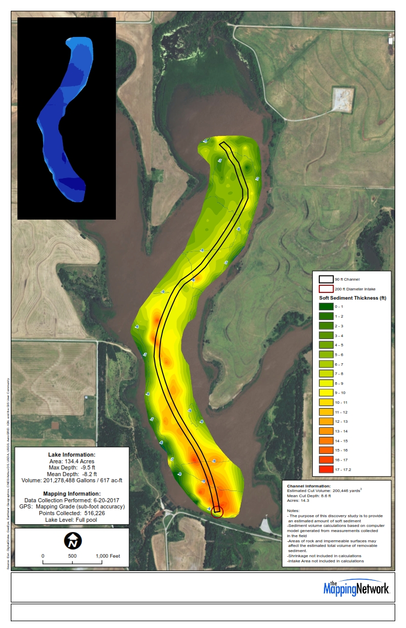
The Mapping Network performed a pre-dredge and sediment study on a county reservoir. Their mission was to locate a historic channel buried under several feet of soft sediment. The Mapping Network had to carefully examine the sonar readings and sediment probe information to best locate the channel. The result of the analaysis providing accurate information to plot the idea course for the dredger to input into their Dredgepak software system.